Europe Map Color Separated Country: A Designer's Toolkit
When you're building a project that centers on geography—whether it's a travel blog, a logistics company website, or an infographic for a school report—the map itself becomes a core piece of your brand identity. A poorly chosen map can make a design feel generic or cluttered. That's where a resource like the Europe Map Color Separated Country collection steps in, offering not just a map, but a versatile set of design assets built for real-world use.
Visual Style and Personality
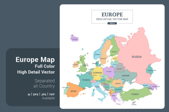
This isn't a single static image. It's a toolkit of four distinct styles, each with its own personality. The Full color High Detail version is vibrant and immediately recognizable, perfect for projects where clarity and visual appeal are paramount. The Monotone High Detail style offers a more sophisticated, unified look, ideal for integrating into a specific color palette without overwhelming other design elements. For a cleaner, more technical feel, the Outline Stroke High Detail version provides precision with its defined borders. Finally, the Outline Stroke Less Detail style on a green background is a minimalist's dream, offering a simplified, modern aesthetic that works beautifully as a subtle background or a bold focal point.
The square shape (5000x5000 pixels) is a practical choice for today's digital landscape, fitting perfectly into social media posts, presentation slides, and website headers without awkward cropping. The high resolution ensures it looks sharp whether you're printing a poster or zooming in on a specific region for a web design element.
Practical Applications Across Projects
Think about the last time you needed a map. Maybe you were creating a presentation for a client expanding into new markets. A clean, color-separated map allows you to highlight specific countries with ease, drawing the audience's eye exactly where you need it. For editorial design, a magazine article about European cuisine or history could use the full-color version as a stunning visual centerpiece, with each country's distinct color helping to anchor the narrative geographically.
Entrepreneurs and small business owners will find immense value here. If you run a shipping company, the outline versions can be adapted into a clean logo element or an infographic explaining your service routes. Content creators and bloggers can use the maps as a base for custom pins, travel diaries, or interactive elements on their sites. The included file formats (.AI8, .EPS8, .JPG, .TIF) mean you're not locked into one software. Whether you're working in Adobe Illustrator for a complex packaging design or using Canva for quick social media graphics, you have the right file at your fingertips.
Choosing and Using Your Map Asset
Selecting the right style from the four options is your first decision. Consider your project's overall tone. Is it playful and informative? The full-color map might be your best bet. Is it corporate and sleek? The monotone or detailed outline could be more appropriate. Always test the map within your actual layout. Place it next to your chosen typography—a sans serif font for a modern feel, or a serif font for a classic touch—to ensure visual harmony.
The true power of this asset lies in its simplicity to customize. Because the countries are separated, you can easily adjust colors in a vector editing program to match your brand identity precisely. Need to resize it for a favicon or a large banner? The vector formats (.AI, .EPS) scale infinitely without losing quality. This flexibility makes it a premium font-like asset for visual content; it's not just a picture, it's a foundational element you can build upon.
Remember, a map is more than just geography; it's a visual story of connection, culture, and commerce. Having a high-quality, adaptable map collection like this in your toolkit saves time and elevates the professionalism of your work, allowing you to focus on the message rather than struggling with the medium.